Paul Tobias Software www.PaulTobias.com |
|
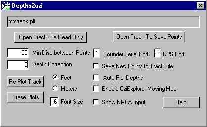
Depths2Ozi - A Freeware Program for Marine SurveyingSummaryDepths2Ozi allows you to collect depth readings using an NMEA depth sounder and plot the depths with the OziExplorer mapping program (www.oziexplorer.com). It accepts 1 or 2 serial NMEA inputs for GPS and Depth Sounder, and can create an OziExplorer compatible track file that both shows the minimum depths between points and includes decimal points in the depth (unlike the tracks produced by OziExplorer). At the same time, it can optionally plot the depths (as OziExplorer “map comments”) on OziExplorer in moving map mode. Pre-existing track files (created by OziExplorer or Depths2Ozi) may also be plotted (in meters or feet) with correction for depth of transducer or tides. The frequency of plotting can be controlled by setting the minimum distance between points. Depths (altitudes) less than 10 feet (or meters) will be plotted showing one decimal point. Depths plotted may be easily erased and re-plotted with different depth corrections or spacing without affecting the original track file. Recording Track files using Depths2OziTo make a new track, attach your GPS and Depth Sounder to the chosen serial port(s), then click Open Track to Save Points and choose a name for the track file. If you choose a track file name that already exists, then the new track points will be appended to the end of the track file. To make new tracks, Depths2Ozi (D2O) needs to receive both the depth sounder and GPS inputs, so don’t first start OziExplorer in moving map mode, or D2O may not be able to open the GPS serial port. Instead, use D2O to collect the data and if you want to simultaneously display the position, send the GPS data on to OziExplorer by clicking the Moving Map and/or Auto Plot buttons in D2O. The Depth sounder and GPS NMEA inputs may be received on the same or two different serial ports, it doesn’t matter. The serial ports are labeled GPS and Sounder only as a hint to the user. In fact they are interchangeable, and if both sets of data are coming in on one serial line, then one serial port should be used with the other set to 0. USB to serial adapters work OK for systems without serial ports. If you click the Show NMEA Input button, then the input data will flash by on the bottom line of the dialog, giving you a crude way of determining that both a serial port and its attached device are working. Both D2O and OziExplorer with sounder attached will insert the depth into the altitude field in the track file. D2O will include any decimal points and saves the minimum depth between points, which, for depth charting, is more useful than the track files made by OziExplorer. The Min Distance Between Points controls the frequency of points saved. Tracks may always be later plotted with a greater distance between points, so it may make sense to save tracks with a smaller distance between points than you expect to need on the chart. Even while saving points to a new track file, you can use the re-plot track button to re-display the points so far seen. Plotting Tracks on OziExplorerYou can plot the depths in track files made by OziExplorer, or D2O over an OziExplorer displayed map (or chart). After opening OziExplorer and loading the appropriate chart, click Open Track File Read Only and choose the track file that you want to plot. Adjust the Min Distance Between Points, Depth Correction or Font Size as you wish and click Re-Plot Track to re-display the depths. Note that you won’t see the track unless you are scrolled to the correct area in an OziExplorer displayed map. The depths are plotted from the altitude fields in the track file. Depths under 10 (feet or meters depending on the setting) will be plotted with a single decimal point. You don’t need to use the serial ports while plotting existing track files. So if you wish to use the serial ports for something else (e.g. OziExplorer itself) while plotting old tracks, just set both serial ports to zero. LimitationsDepths2Ozi works with OziExplorer version 3.95.2 or later, and Ozi API 1.05. or later. The XP version had been much tested. A dry tested beta version of Depths2Ozi that works with Windows 10 and probably with Windows 7 & 8 is now included in the distribution. Reports about using this version would be particularly welcomed.
The program uses NMEA sentences GPGGA (GPS position fix) and SDDBT (Sounder Depth Below
Transducer) and passes GPVTG
to OziExplorer GPVTG for boat heading.
Let me know if you use a GPS receiver or depth sounder that doesn’t
emit these sentences. D2O does not switch map datums according to the track file contents. It
is assumed that the track file and OziExplorer are both using the same map
datum. OziExplorer limits the number of displayed map comments (currently to 500), so after 500 depths are plotted, earlier depths are erased to make space for the later ones. There are several workarounds for this:
When plotting the NMEA data in moving map mode, early versions of OziExplorer (vn. 3.904J at least) would hang the computer if it was set to switch maps automatically and Ozi tried to switch maps when Depths2Ozi sent it a new Moving Map position. The workaround is to turn off the automatic map switching, and change maps manually after turning off Moving Map in D2O. After changing maps you probably will want to re-plot the points already saved by clicking the Re-Plot Track button InstallationDownload and unzip Depths2ozi.zip into a folder of its own and enter the WinXP or Win10-7 installation folders appropriate for your Windows version. Installation details are provided in the folder. Once D2O is running, you will probably want to right click a depth plotted on Oziexplorer, and change the default background color to your liking. If you choose "Transparent", then the box surrounding the depth will disappear making the plot look like a normal chart sounding. Click the "Default" button on the right click menu to set your choice for future plots (then go back to D2O and replot the current track to make sure that you like it.) On D2O versions prior to 1.19, the background color was fixed at silver grey. Now you can choose your own. Problem ReportsI am definitely interested in hearing how you use this program, in fixing problems, and in hearing suggestions for improvements. Please contact me at email:If you are reporting a crash or installation problem, please let me know at least the version of the operating system that you were using, the versions of OziExplorer, and the OziExplorer API, and what you were doing at the time. DownloadDepths2Ozi.zip (456 KB) The release includes 2 versions of Depths2Ozi.exe, OziAPI.dll, and Depths2Ozi.doc History
|
Last modified: Friday July 06, 2018. |